BELA - BepiColombo
BELA
BepicolomBo laser altimeter
Science goals
The BepiColombo Laser Altimeter will characterize and measure the figure, topography, and surface morphology of Mercury. It will provide absolute topographic height and position with respect to a Mercury centred coordinate system. This information will be used to create a digital terrain model that allows quantitative exploration of the geology, the tectonics, and the age of the planet's surface. In synergy with the stereo camera STC (as part of SIMBIO-SYS) BELA will increase the knowledge of Hermean geology, such as surface morphology, surface dating, tectonics, volcanism, and the evolution of the planet.
MEASUREMENT PRINCIPLE
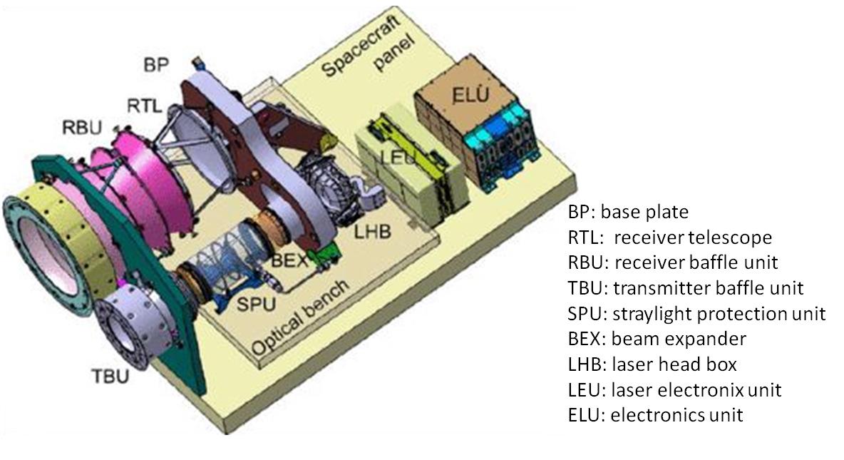
BELA uses a classic approach to laser altimetry. The beam produces a spot of 20-50 m on the surface. The laser beam is reflected from the surface and around 5 ms later it is received with the telescope. The image is refocused and then the signal is sampled and fed to the pulse discrimination electronics. This system determines the time of flight, the integrated pulse intensity, and its width. A digitization system will return the full shape of the return pulse. The data are passed to a digital processing unit which controls the operation and services the spacecraft interface. Onboard data compression and data storage are foreseen. The experiment requires significant baffling and thermal control but can also operate over the dayside hemisphere allowing optimum data acquisition over a minimum duration.
BELA will provide 2 ns time resolution which is commensurate with the expected knowledge of the spacecraft position. Optimum data return is expected at altitudes up to 1050 km above the surface. Samples will be acquired every 250 m on ground-tracks separated by 25 km at the equator crossing at the poles. Over the lifetime of the mission, data points will be 6 km apart decreasing with latitude. The experiment will provide return pulse intensity and width information allowing an assessment of surface albedo and roughness at ~20-50 m scales including in unilluminated polar craters.
Once on ground, acquired data will be converted into ranges initially with the support of orbit reconstructions. Data will be radiometrically calibrated to provide local surface roughness and albedo plots. Local topography maps will be derived almost immediately. Global topographic and shape maps and detailed products (e.g. centre of mass, centre of figure, oblateness) will require analysis of the full data set. Incorporation of the radio science and (possibly) stereo camera data will be required to derive global and regional terrain models, crustal thickness maps and the tidal flexing result.
link to science datasets - COMING SOON
Link to user manual