 Sign in
FoV3D - Meteor
Field of view visualization using 3D GIS software (FOV3D)
Introduction
To get a better understanding of the atmospheric volume that is monitored by a (meteor) camera, one may use 3D GIS-software such as Google Earth to interactively explore the field of view of a camera. To do this, we created a PHP-script called "FOV3D". The script generates a 3D semi-transparant polygon representing the field of view of a given camera.
The script produces output in the KML-format, which is an XML-based language for describing geospatial data. KML-files can be imported into GIS-software such as Google Earth, NASA World Wind and ArcGIS. However, the files generated by this script have only been verified to work with Google Earth.
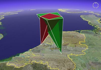
Example of a FOV3D-generated file in Google Earth, showing the MRG double-station setup in the Netherlands.
Simple user interface
Use the form below to create a Google Earth-file for your camera setup.
Notes:
|
Source code
The FOV3D source code is available here: FOV3D.class.php. The interface: fov3d_interface.php.
Please report bugfixes and improvements to Geert Barentsen.
- Removed a total of (1) style text-align:center;
- Removed a total of (1) align=middle;
- Removed a total of (1) align=top;
- Removed a total of (4) style font-weight:bold;
- Removed a total of (30) style margin:0;
- Removed a total of (40) style padding:0;
- Removed a total of (1) align=center.